
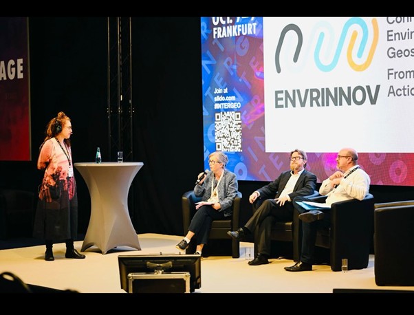
As part of ENVRINNOV’s mission to establish synergies with key actors of the Research and Innovation ecosystem, and plan for the successful implementation of the ENVRI Innovation Roadmap, project partners took part in the INTERGEO Conference in Frankfurt, Germany, on 7 October 2025.
The ENVRINNOV-led session brought together experts from European environmental research infrastructures to discuss how long-term environmental data can be better integrated into geospatial applications, supporting science-based decision-making and sustainable development.
The session, hosted by Mariana Salgado (ICOS ERIC), included talks by three experts from leading Environmental Research Infrastructures (ENVRIs):
-
- Jaana Bäck (eLTER RI) – ‘Long-term ecosystem data for geospatial applications’
- Tuukka Petäjä (ACTRIS ERIC) – ‘Atmospheric data and remote sensing synergies’
- Leo Rivier (ICOS ERIC) – ‘Carbon flux data validation’
Together, the speakers showcased how ENVRIs contribute to advancing open science and innovation in the geospatial domain. Their presentations addressed three main themes:
- What ENVRIs offer: Open-data principles and the diversity of research infrastructures, such as ICOS’s flux towers, ACTRIS’s aerosol observations, and eLTER’s long-term ecosystem monitoring.
- Data and project highlights: Live demonstrations of key geospatially relevant datasets and current innovation projects.
- Innovation gaps and opportunities: How the geodesy and geoinformation communities can further leverage ENVRI data beyond academia—for example, in commercial applications.
Following the presentations, participants took part in the interactive “Hack the ENVRI DATA” challenge, proposing practical applications of ENVRI data — from urban planning to precision agriculture. The exercise encouraged lively discussion on data accessibility, usability, and opportunities for closer collaboration between environmental and geospatial communities.
INTERGEO is the world’s leading trade fair for geodesy, geoinformation, and land management, offering a key platform for cross-sector exchange and innovation.
The session was jointly organised by ICOS, eLTER, and ACTRIS under the umbrella of the ENVRINNOV project. By demonstrating the potential of shared data and tools, the ENVRINNOV session at INTERGEO 2025 showcased how greater cooperation between the environmental and geospatial sectors can lead to new insights and better-informed decisions for a sustainable future.
“Funded by the European Union. Views and opinions expressed are however those of the author(s) and do not necessarily reflect those of the European Union or REA. Neither the European Union, nor the granting authority can be held responsible for them.”